The beaches in Ucluelet, the site of today’s adventures, do not resemble the surfer’s paradise of California. Nor are they the long spits of sand from Oregon, the kite-flyer’s runways. These would fit the dictionary definition of rugged, full of rocks and treacherous tides. Welcome to Canada.
Walking the Wild Pacific Trail
Driving over to Ucluelet from Port Alberni was adventure in its own right. The roads were twisty, which was to be expected, but it rained steadily and there were two long stoppages for construction. While we wanted to cast aspersions on the traffic annoyance, we were forewarned, and the views were spectacular. Even the rainwater falling off rocks at the construction site was dramatic.

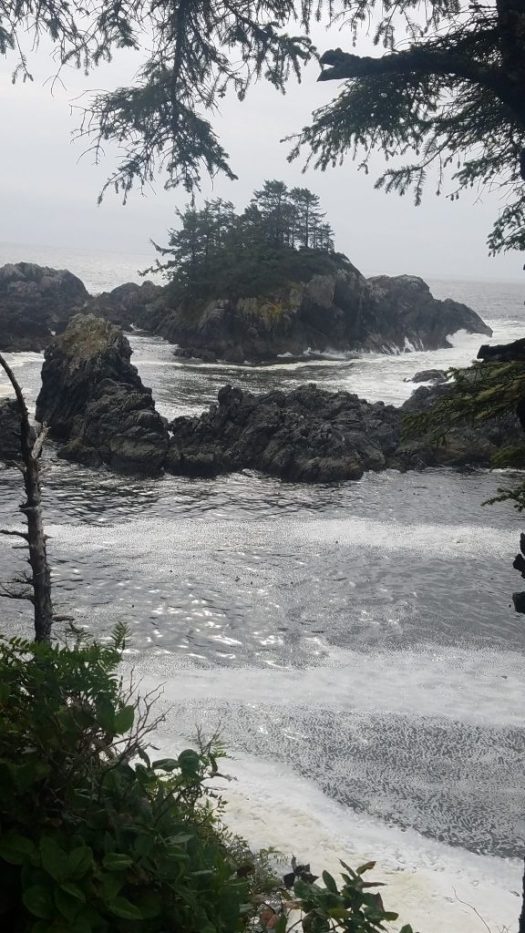
At last, we were in Ucluelet, a little fishing? tourist? village, on the southwestern inside edge of Vancouver Island. There are a series of trails that wend along the side, the easiest being the Wild Pacific Trails near Ucluelet beaches. We started with the loop that took us through a bog, past a tsunami warning, and out to a small lighthouse.
Squatter Lighthouses
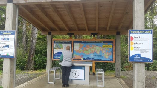
They take their tsunamis seriously here, so seriously that your first stop off the parking lot is a lengthy warning of exactly what to do in case of… I’m trying to imagine if you got off the tour bus at Fisherman’s Wharf and the first thing you saw was a large display discussing what to do in the event of an earthquake. Might be handy, actually. Might put some of the tourists back on the bus.
But tsunami warnings are there for good reason, as the first lighthouse built out on Amphitrite point was swept away by a tidal wave only a few years after its construction. The second one required a hardy crew to drag equipment through the mud for months, even during the intense stormy season. The building itself is squat and short, designed like a bunker to withstand the annual battering.


Graveyard of the Pacific
The reason for the shape of the lighthouse becomes clear when you learn about what happened to ships sailing up the west coast. One notable wreck was the Pass of the Melfort. She was a British, four-masted, 2346 ton vessel that had started down in Panama. The aim was to sail over to Seattle for a load of timber, and she was planning to meet the Broderick Castle, after the Captains had met in Southern California. Broderick made it, but the Melfort was late.
The ship had been caught in a storm that pulled it up the Strait of San Juan de Fuca and into the rocks off Amphitrite point. There is speculation that too few hands were on board to handle the ship, but it is known that all were lost, drowned a few dozen yards from shore. First Nation people were alerted by the distress calls from the ship, but they could only watch. Only a few broken lifeboats, buckets with the ship names, and timbers remain.
Off the coast of Japan, a wave forms and then intensifies as it propagates four thousand miles eastward across the Pacific Ocean. High above, westerly winds gather moisture-laden clouds as they blow over the warm waters. When both of these elements meet land for the first time, it is a force to be reckoned with….Welcome to the west coast of Vancouver Island, where warm moist air masses, forced upward by the island’s mountain ranges, dump their weight of water on the coastline below as ferocious waves pound the rugged shore.
from lighthousefriends.com
The coastline north from Washington, where over 2000 ships have been lost, has a nickname: “Graveyard of the Pacific.”

Artist’s Loop
We walked more of the Wild Pacific Trail, a coast-hugging meander that offered one stunning view after another. It was, aptly named, the Artist’s Loop.

Even the trees were dramatic. This one reminded me of Tolkein so much that I expected to see Tom Bombadil pop out at any minute.

Candied Salmon
After two hour-long walks, we deserved a good, late lunch. The fish, as expected, was outstanding. Dungeness crab comes from right across the Strait of San Juan de Fuca, while you have choices among varieties of wild salmon. We selected the Cedar Grill, a nondescript little pub in a strip mall in town but were rewarded with an amazing trio of smoked salmon cream cheese, candied salmon, and bacon-wrapped scallops.

I told the server that I would go out on a limb and say that those were the best bacon-wrapped scallops I would ever have. I think she told the chef because I heard a “Woohoo!” in the kitchen. There might have been beer-battered fresh fried halibut. There might have been sweet and spicy edamame beans.
Next stop thataway is Hawaii, assuming you could handle the storms and the currents, which most likely would take you elsewhere.

Our next stop is Tofino.
bacon-wrapped scallops – I am bookmarking this place because I LOVE bacon-wrapped scallops,
If you come this way again you might want to walk the Hobbit Trail just north of Heceta Head.
We must!